Valley of Fire – Day 1
We left Buffington Pockets in time to get to Valley of Fire State Park in Nevada, at sunrise. The road into Buffington Pockets follows a dry wash, and was very rough. Driving back out was a crawl, and made it hard to drink my coffee, without wearing it. Once down on the flat, the road smoothed out, and we were able to make better time. Before we lost cell service, we stopped to check the weather report. The next afternoon looked windy and wet, so we needed to get in our exploring before then.
We stopped at Mouse’s Tank Trail first, hoping to find some sheep to photograph, because this was an area they supposedly hung out at. There were no sheep hanging out there, and we did find a few petroglyphs along the trail, but it looked like some vandalism as well.

Gauge was exploring this cave, and we meet in the middle. I was laying down and shooting through a small opening at the end of the cave.

Our next stop was Fire Canyon. I love the different colored layers in this photograph.

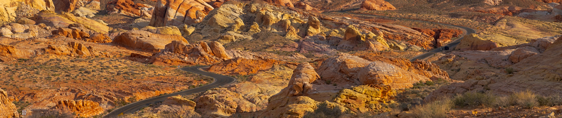
White Domes Road runs north from the Visitor’s Center to White Domes Loop Trail. It is about 11 miles total, out and back. The park got quite crowded later in the day, but if you were up early, there were only a few people out. The sun was still low in the sky in this image.

Next we drove to parking lot number 3, and explored on the west side of the road. There are only a few parking lots along the road, and no parking along the side. It also has a 25 mph speed limit, and the Park Rangers were enforcing both.

We did not spend too much time exploring, as we wanted to make it to the campground at the magic hour. That is 8-8:30 am, when you are most likely to find an empty spot. When we got there, there was only one open spot, which we grabbed. After we paid our fees, tagged the post and made the site look “camped in”, we headed to the Visitor’s Center. We read about the history of the park and looked through the displays inside. It was worth the stop. Just outside the Visitor’s Center is the “Scream”

Somehow I forgot my book at home, so we headed out the east side of the park toward Overton, Nevada. We found a thrift store that had hardbacks for $1.00 and paperbacks for $.50. We stopped at Overton Wildlife Management Area on the way back and saw a variety of waterfowl and other birds. Then we looked at some other places to hike to near the East Entrance for later in the day or tomorrow. We decided to stop and take a shower at the main campground, on the way back. After our shower, just as we had begun to drive back to Arch Rock Campground, two Black Hawk helicopters flew overhead. Zoomed in, you can see people sitting on the edge with their legs hanging out the doors.

We headed back out to hike to the Fire Wave for sunset. Valley of Fire is only open from sunrise to sunset, unless you are in a campground. That is too bad, as there would be some awesome spots for Milky Way photography. About a half hour before sunset, the clouds were hiding the sun. Every group of people there wanted to pose on top of Fire Wave. I waited patiently for each group of people to have a turn, and then clear out, then I took this image.

Just before the sun dropped below the horizon, the clouds parted, and the sun lit up the Fire Wave. Two California Bighorn ewes were scrambling across the rocks to the west, however I had left my 100-400 mm lens back at the truck to save weight on the hike. Figures… “I won’t need it for this hike”, Duh. Then I spotted two idiots chasing the two sheep, probably at night is the only break the animals get from the humans. Maybe that is why the park closes at sunset.

Different colored layers are eroded and exposed from the ancient sand dunes. The range of colors of the Aztec Sandstone –red, brown, pink, salmon, gold, and even white—results from varying amounts and forms of iron oxide within the rock, and in the case of the white, the overall lack of iron. The Aztec Sandstone is an Early Jurassic geological formation, and is exposed in the Mojave Desert. Aztec Sandstone is named after the Aztec Tank, a lake in the Spring Mountain region of Nevada.

Back at camp, we started a fire and cooked some dinner. The weather was about 10 degrees cooler than normal for this time of year. Most days were only 58 – 62 degrees for the high, and the fire took off the chill.

Valley of Fire State Park – Day 2
We woke up before sunrise and drove the loop road south of the campgrounds. I was hoping to see some bighorn sheep, but the two ewes we saw last night were the only ones we saw. The sunlight on the clouds reminded me of orange cream sherbet.

One of the iconic shots in Valley of Fire. I used a 100-400 mm at 220 mm to compress the scene, and make the mountain in the background seem to loom at the end of the road.

You are not supposed to park along the road, so we made a quick stop and Vicki let me out at Pink Canyon. The speed limit is 25 mph on White Domes road, I wasn’t worried about the Rangers, since they just pulled over a car that went speeding past us. The sun was behind a ridge, so there was not any direct light on the canyon. I was kind of amazed that a plant could grow here.

Pink Canyon, what an appropriate name.

When hiking in a canyon, you should always be aware of your surroundings. You never know what may be lurking and watching you around the next corner.


If you have been to Valley of Fire and did not do any off trail hiking across the rock, why not? Just Do-It.

Layers upon layers of different colored sandstone.


The wind had started to pick up speed, and rain was forecast for the afternoon. I did not relish getting sandblasted, so we decided to head east out of the park and explore our way down to Hoover Dam. We stopped at the Cabins, before we left the park. The cabins were constructed by the Civilian Conservation Corps (CCC) in the 1930s, for traveling tourists. It is now a picnic area at the park.

This was Gauge’s view out the cabin window.

We drove down North Shore Drive in the Lake Mead National Recreation Area. Lake Mead is currently 183 feet below full pool, there is a giant “bathtub ring” around the lake. We stopped at Echo Bay along the way and the boat ramp was closed, due to low water levels. The water appeared to be far below the bottom of the ramp.
You can see the “bath tub ring” on the rocks above Lake Mead, behind Hoover Dam. The lake level is only 40 feet from “dead pool”, which means flow and hydropower for all practical purposes will stop. This would be catastrophic for cities, farmers, wildlife and tribes downstream. The water allocation reduction process currently being fought over needs to move forward, and quickly!
The photograph below was taken from the walkway along the Hoover Dam Bypass Bridge (Mike O’Callaghan-Pat Tillman Memorial Bridge). The bridge crosses the Black Canyon between the states of Arizona and Nevada. The wind was gusting about 35 – 40 mph, I was holding onto my hat and some women were holding onto their skirts. Since we walked more than halfway across the bridge, Vicki can no longer say I never took her to Arizona.

We stopped at the east end of Valley of Fire on the way back to camp. The sky was spitting rain on us as we checked out more eroded rocks, and arches.

After a long day out exploring, we came back to camp. In between intermittent rain showers, the sky lit up for about 2 minutes. Just long enough for me to capture this image. We sat in the pickup and read by the light of a mini lantern, listening to the rain on the roof. Arch Rock Campground is one of the prettiest pay campgrounds we have ever stayed at.

Previous Post – Gold Butte National Monument to Buffington Pockets
Next Post – Bowl of Fire

