Petroglyph Area
I awoke before the sunrise, and headed back to the petroglyph area for further exploration. The photograph below shows a different view of Falling Man, which is in the upper right corner of the image below, in the desert varnish (darker stains on the rock). Notice how far up Falling Man is, it was at least 9 feet up, and I have to wonder how the Natives got up there. There could have been a spot to scramble down the cliff from where I stood, but with my camera gear, I was not going to attempt it. The “normal” path is to go behind the large boulders on the left, after crawling through the cave.

The “strings” that were pulling off the Yucca leaves were interesting, as well as the multiple layers and colors in the sandstone.

Calvin’s Rock had some petroglyphs on it, but was hard to photograph once the sun came up further. I initially bypassed it to explore further from the trail.

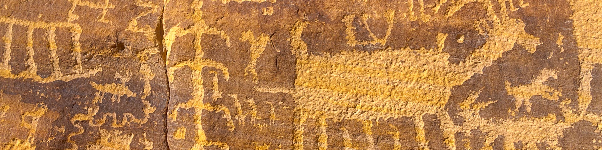
21 Goats Panel
After my sunrise exploration, I headed back to the pickup and woke up the crew. It is always best to offer my wife coffee, right after I tell her to get out of bed. Gauge sat up and announced, “I’M AWAKE”. We grabbed a bite to eat, to go with our coffee, and drove further down the road to the 21 Goats Trail. It was about 1/3 of a mile to the petroglyph panel, from the small parking area. Why do they call it 21 goats when they are sheep? There are more than 21 sheep in the petroglyph, however there are only 21 in the top row. This is a 5 image panorama, the panel is about 30 feet long.

The photograph below shows the lower part of the 21 goat panel. First I wondered how many petroglyphs have eroded away, then I wondered if my grandchildren’s grandchildren would even see a difference in the panel in 100 years.

Khota Circus Petroglyph Panel
We drove to the trailhead for Khota Circus next. The road went past an area they installed cables on both sides of the road, to help protect the Bear Paw Poppy, and desert crust. Cryptobiotic soil (desert crust) grows at an extremely slow rate of about one millimeter per year. So, any soil crust that is disturbed can take a very long time to recover. Depending on the amount of moisture the area receives, it can take anywhere between 20 and 250 years for soil crust to grow back. The road was a literal roller coaster, with no place to pull over, thankfully we never meet another car. Vicki and Gauge stayed at the pickup, so I was on my own. The trail followed a dry wash below Black Butte.

Then the trail crossed a sandy flat, eventually lead to this spot. The trail drops into the wash and back up the other side, then heads for the sandstone ridge area in the upper right of the image. I saw signs that wild burros had been there, but I did not see any.

Once I hiked to the sandstone ridges, the trail drops into a draw between ridges.

Once I got down to the bottom, I spotted this small panel high up on the opposite ridge.

Khota Circus Panel is supposed to be about 75–90 feet long, with very detailed petroglyphs, like the one above. My plan was to find and photograph it, but I had trouble finding the large panel. I found this panel, which is about 40 feet long. This is a 9 image panorama, and it is difficult to see due to the harsh sunlight.

I would have spent more time looking for the Khota Circus Panel, but I did not plan well enough. I thought it was only about 2.2 miles round-trip. However, it was closer to 3.5 miles roundtrip on the trail, not counting the distance I traveled in the bottom of the draw looking for the panel. I decided to leave when I had 1/3 of my water left. I should have brought 1/2 gallon, instead of a quart, and this was only a 60 degree day.
You can see the marks in the rock, where the desert varnish was “pecked”, with a bone or antler. There are very few rocks hard enough nearby, so I am assuming it was a bone or antler that was used.

We left Gold Butte National Monument and drove to Mesquite, Nevada to pick up some ice. One hinge on the cooler had broken, but there were no hinges at Wally World. The sporting goods clerk didn’t think it was funny when I asked to borrow a phillips head screwdriver, because I could see hinges that would work.
We left Mesquite and drove south on I-15 to Valley of Fire Highway. We came in from the west, instead of Overton, NV on the east because I wanted to see where the turnoff to Buffington Pockets was, in case we could not get a campsite at Valley of Fire State Park. It was late afternoon as we approached the entrance to Valley of Fire. There were a lot of cars leaving, and only a few backed up waiting to get in. We were stuck in the middle of the entrance line, when I saw the “Campgrounds Full” sign. Once we got to the pay window, I asked what the best time to get a campsite was, and the ranger said 8:30 – 9 am.
Buffington Pockets
We turned around, without paying the entrance fee, and left the park, heading back toward Buffington Pockets. I took almost an hour to drive from the park entrance to where we camped, since the last two miles were a “5 mph road”. Vicki sat in the sun and read her book, while Gauge and I explored. There were a few more petroglyph panels further up this draw. One large eroded cave, that took a scramble to get to, had sheep tracks inside. I guess it was a good lookout spot.

This was our camping spot for the night. Once it got dark, I thought about trying to get some Milky Way images, since the clouds had cleared out. However, we were too close to Vegas and the light pollution spilled over the night sky, it would have ruined a Milky Way photograph.

The colors of the Aztec – Navajo Sandstone in Buffington Pockets were a wide range, with many different layers. Here we have blue-green, pink, tan, orange, magenta, red and yellow.

Previous Post: Gold Butte National Monument Petroglyph Area Next Post: Valley of Fire State Park

