In March 2024, we headed to Joshua Tree National Park with our 9-year-old grandson along for the trip. He loves to hike and camp, and he was out of school for spring break. We arrived at Black Rock Campground right at dusk. Joshua Tree National Monument was put in place in 1936, later on as part of the Desert Protection Bill, Joshua Tree National Monument was elevated to National Park status on October 31, 1994
I had planned to do some exploring before it got dark, but we had a couple of delays on the way. We had to fix a latch on the camper and get some supplies that we forgot, which delayed us a couple of hours. It was windy that night, the campers next to us put a tarp over their tent, and it was flapping hard all night, a bad decision. We left before daylight and headed to the West Entrance Station and then to the Barker Dam trailhead.

There was some water behind the dam, but the sky was clear with no color. Looks like a black and white morning, with minimal clouds and no sky color. I had recently purchased the TK Mixer plugin for Photoshop and enjoyed editing the black and white images that are in this blog post. I have found better results with the TK (Tony Kyper) Mixer than Silver Efex Pro.
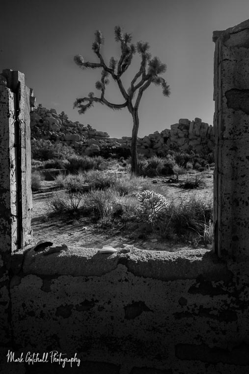
There were the ruins of an abandoned house along the way, and lots of Joshua Trees on the Queen Valley floor, surrounded by granite outcroppings. The temperatures were about 10 degrees below normal during our trip, and this was a cool, crisp morning.

Since I did not plan far enough ahead for our trip, we ended up staying at a new campground every night we were here, and our next stop was Cottonwood Campground. Along the way, we stopped for some short hikes in Wilson Canyon.

We met a friend at the campground who had driven from San Diego with her boyfriend. They hung out until late afternoon, catching up on what was happening in our lives, then they drove toward the west entrance. She had never seen Joshua Tree NP, even though she grew up in San Diego. Gauge decided he wanted to hike up Mastodon Peak with me. I was not sure whether he would make it, but he did great. He loved to scramble on the large granite boulders. Near the top, you could look down and see the Salton Sea.

Day 2
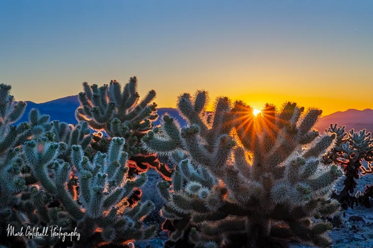
On day 2, we left early for the Cholla Cactus Garden to arrive before sunrise. Setting up a composition was interesting, making sure to watch all body parts for the spines of the Teddy Bear Cactus, also known as Jumping Cholla. I carried a Leatherman where I could reach it with either hand, in case I got too close. Luckily, I only had to pull spines from my hiking shoes and not my skin.

After sunrise, we made our way to White Tank area and hiked to Arch Rock and Heart Rock.

We had signed up for the Ranger-led tour of Keys Ranch. The property is located in a remote, rocky canyon in Joshua Tree National Park. The cost for adults at the time was $20 each, and it was worth the cost. It was an informative tour with information about Native American history, mining, ranching, homesteading, the Keys family, and the site’s transition into a protected historical site. Bill Keys was a miner and a scrounger who picked up what he found, maybe even if it was not abandoned. The family had an open-air market selling miscellaneous mining tools, equipment, and repair parts. They raised chickens, had a large garden, and small outbuildings for overnight boarders to stay.


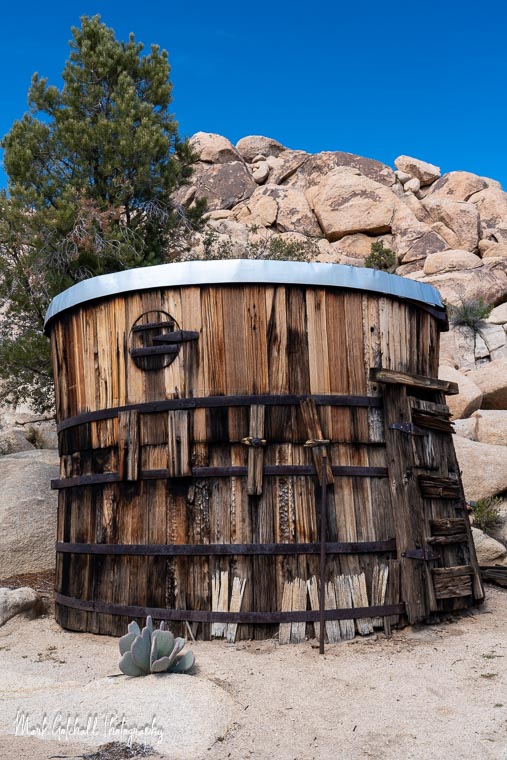
Bill Keys stored his horse tack in a small building that was made of two cyanide vat barrels. Cyanide was used in gold mining to help extract the gold. It is amazing that with all the harsh chemicals he was exposed to, he lived to be 89.

From the Keys Ranch, we made our way to Indian Cove Campground, which is on the north side of Joshua Tree National Park, for the night. You have to exit the park and re-enter the park near the campground. The Visitors Center was on the way, so we stopped to look through the museum, get some park details, and see what they were selling. We relaxed in camp, and because of the location of the campground in a cove, there wasn’t much of a sunset photo opportunity. Gauge played with some kids from the campsite near us, and they were all scrambling over and around the granite boulders. After dark, the kids had smores at the neighbor’s campfire while the adults sipped a beer.

Day 3
On Day 3, we went in search of the Eagle Cliff Boulder House. The miner’s house is mostly intact and is built into the cliffside using the large boulders as the main wall, with a cave inside. The gaps were filled with smaller rocks, morter and tin cans for roofing material. There are two ways to get here, and neither one is signed, maintained, or on the park maps. It takes scrambling over boulders, on scree slopes, and navigating off-trail to find your way. It seems to have weeded out the vandals and thieves, as it seemed like many of the abandoned items were still there, with no graffiti present. If you are interested in going there, I used Gaia to navigate, and I would be willing to share coordinates.


My grandson had done the Mastodon Peak hike with me, and I thought he was ready for this scramble. The climb is steeper and longer than it looks from the picture. The highlighted area in the saddle is two hikers, which you can see if you zoom in. Gauge was not happy with the climb up, but he was in panic mode when we made our way down due to the loose rocks. After the first meltdown, I told him to hold my hand, and I would help him down the hill. That calmed him down, and he was able to make the descent to the easier area of the route.

We drove down the Geology Tour road to find a place to eat lunch and get away from the crowds. Along the way, I saw these two Joshua Trees, and they appeared to be holding hands. I felt it summed up our hike down from the Eagle Cliff Boulder House. Hold my hand, and I will help you along the way. This image means a lot to me because of the reminder of that day.

Joshua trees have branches that look like arms, named by Mormon pioneers who thought they resembled the prophet Joshua raising his hands in guidance; these “arms” are actually new stalks that grow after the tree flowers, splitting off at the tip, creating their iconic, spiky, and often chaotic look, with more branches indicating more blooms over its long life.
The Joshua tree (Yucca brevifolia) is the namesake of Joshua Tree National Park and a defining feature of the Mojave Desert. Once classified as a giant lily, modern DNA research has placed it in the Agave family. Like the California fan palm (Washingtonia filifera), the Joshua tree is a monocot—part of the same botanical group that includes grasses and orchids.
Vicki fixed lunch while Gauge and I explored trails along a boulder hill. He was on his way to getting over his fears from earlier that morning.

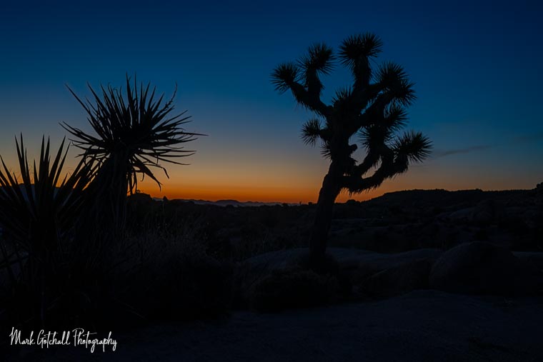
We spent that night at Jumbo Rocks Campground, and Gauge found more kids to play with there. I wandered around on trails near camp looking for special compositions, but never found one that made the grade. I did find Penguin Rock and located the spot I wanted to take a sunset photograph from. There was a queue to shoot the iconic image, and I awaited my turn to capture the image below.

Day 4
On day 4, I arose before the sun to photograph the early morning hours. There was a nice orange glow on the horizon before the sun came up.
The moon was almost full and was close to setting as the sun rose and began lighting up the landscape.


After coffee and some breakfast, we headed toward the Mojave National Preserve. Along the way, we stopped at Roy’s Motel and Café on Route 66 in Amboy, California. The current owners are slowly restoring the motel and hoping to get the café up and running. It is good to see a piece of history being restored. We have plans to explore more of Route 66 in Arizona and New Mexico.

We drove through the Mojave National Preserve and only stopped at Kelso for a look. Unfortunately, the old depot was closed for repairs, so we were unable to explore the inside, but we pressed our noses to the glass and read what we could see.
The steep two percent grade that trains had to climb from west of Kelso to Kessler Summit (later renamed Cima) meant that extra “helper engines” would need to be stationed nearby to help them up the grade. Additionally, steam locomotives of the era desperately needed water. Kelso was perfectly situated to fill both roles, since it is located near the bottom of the 2,078-foot grade, and had a reliable water source from a nearby spring in the Providence Mountains.
The “Kelso Clubhouse & Restaurant” building opened in 1924. It included a conductor’s room, telegraph office, baggage room, dormitory rooms for staff, boarding rooms for railroad crewmen, a billiard room, library, and locker room. Later, when diesel-electric locomotives replaced steam engines, the need for the depot declined. It was closed in 1985 and became part of the Mojave National Preserve in 1994. It was restored and reopened as a Visitors Center in 2005.

From here, we drove to Death Valley National Park and spent a long, windy night along Greenwater Valley Road. The wind came in gusts that sounded like a freight train as they approached. I got up around midnight to move the front of the pickup and camper into the wind, which helped, but it was no longer level as I did not replace the leveling blocks. It was difficult to get any sleep, but the wind finally died down around 4 am. I planned to shoot the sunrise at the Mesquite Flat Sand Dunes, but I finally got to sleep and woke up about 8 am, well past sunrise.
The next overnight stop was the Alabama Hills, and from there, take a couple of days to drive back home. Now that I am retired, as of August 2025, I plan to drive a maximum of 5-6 hours per day. That will leave more time to photograph, hike, kayak, and fish.
Previous Post: New Bundutec Camper
Next Post: Want to See Big Waves – Forget King Tides

